File:France 1800.png
From Wikimedia Commons, the free media repository
Jump to navigation
Jump to search

Size of this preview: 599 × 599 pixels. Other resolutions: 240 × 240 pixels | 480 × 480 pixels | 768 × 768 pixels | 1,023 × 1,024 pixels | 1,795 × 1,796 pixels.
Original file (1,795 × 1,796 pixels, file size: 152 KB, MIME type: image/png)
File information
Structured data
Captions
Captions
Add a one-line explanation of what this file represents
Summary
[edit]| DescriptionFrance 1800.png |
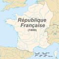
English: Map of France in 1800
Français : Carte de la première république française en 1800 |
| Date | |
| Source | Euratlas - Carte historique de l'Europe en l'an 1800 |
| Author | European citizen |
| Permission (Reusing this file) |
domaine public |
Licensing
[edit]| Public domainPublic domainfalsefalse |
| I, the copyright holder of this work, release this work into the public domain. This applies worldwide. In some countries this may not be legally possible; if so: I grant anyone the right to use this work for any purpose, without any conditions, unless such conditions are required by law. |
File history
Click on a date/time to view the file as it appeared at that time.
| Date/Time | Thumbnail | Dimensions | User | Comment | |
|---|---|---|---|---|---|
| current | 23:01, 5 November 2015 |  | 1,795 × 1,796 (152 KB) | TKostolany (talk | contribs) | suppression des frontières des autres pays car il en manque beaucoup |
| 20:22, 7 June 2010 |  | 1,795 × 1,796 (195 KB) | Brisavoine (talk | contribs) | Added land area. | |
| 03:10, 4 June 2010 |  | 1,795 × 1,796 (191 KB) | Brisavoine (talk | contribs) | Autre correction de frontière dans le Limbourg hollandais. | |
| 01:48, 4 June 2010 |  | 1,795 × 1,796 (191 KB) | Brisavoine (talk | contribs) | Correction de la carte : Genève et Monaco faisaient partie de la République française en 1800. | |
| 01:15, 4 June 2010 |  | 1,795 × 1,796 (191 KB) | Brisavoine (talk | contribs) | Escaut jusqu'à son embouchure. | |
| 01:11, 4 June 2010 |  | 1,795 × 1,796 (191 KB) | Brisavoine (talk | contribs) | Correction de la carte : la Flandre zélandaise faisait partie de la République française en 1800. | |
| 16:25, 19 June 2008 |  | 1,795 × 1,796 (346 KB) | European citizen (talk | contribs) | {{Information |Description={{en|1=Map of France in 1800}} {{fr|1=Carte de la première république française en 1800}} |Source=travail personnel (own work) |Author=European citizen |Date=19 juin 2008 |Permission=domaine public | |
You cannot overwrite this file.
File usage on Commons
The following 2 pages use this file:
File usage on other wikis
The following other wikis use this file:
- Usage on ar.wikipedia.org
- Usage on ast.wikipedia.org
- Usage on bg.wikipedia.org
- Usage on ca.wikipedia.org
- Usage on de.wikipedia.org
- Usage on en.wikipedia.org
- Usage on es.wikipedia.org
- Usage on et.wikipedia.org
- Usage on eu.wikipedia.org
- Usage on fr.wikipedia.org
- Usage on fr.wikinews.org
- Catégorie:22 septembre 2008
- Catégorie:22 septembre 2009
- Catégorie:22 septembre 2010
- Catégorie:22 septembre 2011
- Catégorie:22 septembre 2012
- Modèle:Éphéméride-22 septembre
- Évènements du 22 septembre 2012
- Catégorie:22 septembre 2013
- Évènements du 22 septembre 2013
- Catégorie:22 septembre 2014
- Évènements du 22 septembre 2014
- Catégorie:22 septembre 2015
- Évènements du 22 septembre 2015
- Catégorie:22 septembre 2016
- Évènements du 22 septembre 2016
- Catégorie:22 septembre 2017
- Évènements du 22 septembre 2017
- Catégorie:22 septembre 2018
- Évènements du 22 septembre 2018
- Catégorie:22 septembre 2019
- Évènements du 22 septembre 2019
- Catégorie:22 septembre 2020
- Évènements du 22 septembre 2020
- Catégorie:22 septembre 2021
- Catégorie:22 septembre 2022
View more global usage of this file.
Metadata
This file contains additional information such as Exif metadata which may have been added by the digital camera, scanner, or software program used to create or digitize it. If the file has been modified from its original state, some details such as the timestamp may not fully reflect those of the original file. The timestamp is only as accurate as the clock in the camera, and it may be completely wrong.
| Horizontal resolution | 28.35 dpc |
|---|---|
| Vertical resolution | 28.35 dpc |
| File change date and time | 22:36, 5 November 2015 |